Pikes Peak
| Pikes Peak | |
|---|---|
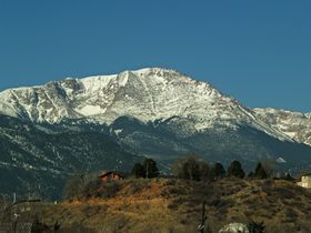
 Pikes Peak towers above the city of Colorado Springs |
|
| Elevation | 14,115 ft (4,302 m) [1] |
| Prominence | 5,510 ft (1,679 m) |
| Listing | Ultra |
| Location | |
| Location | El Paso County, Colorado, USA near Colorado Springs |
| Range | Front Range |
| Topo map | USGS Pikes Peak |
| Geology | |
| Type | granite |
| Age of rock | ~ 1.05 Gyr |
| Climbing | |
| First ascent | 1820 by Edwin James and party |
| Easiest route | cog railroad or drive |
Pikes Peak (originally Pike's Peak, see below) is a mountain in the Front Range of the Rocky Mountains, 10 miles (16 km) west of Colorado Springs, Colorado, in El Paso County. It is named for Zebulon Pike, an explorer who led an expedition to the southern Colorado area in 1806. At 14,115 feet (4,302 m)[1], it is one of Colorado's 54 fourteeners. Drivers race up the mountain in a famous annual race called the Pikes Peak International Hill Climb. The peak is also the annual site of the Pikes Peak Marathon and Ascent foot races on the Barr Trail. An upper portion of Pikes Peak is a federally designated National Historic Landmark.
Contents |
Geography and geology
Much of the fame of Pikes Peak is due to its location along the eastern edge of the Rockies. Pikes Peak is the easternmost fourteen thousand foot peak in the United States. It lies 37 miles west of Colorado Springs (traveling by road). Unlike most other similarly tall mountains in Colorado, it serves as a visible landmark for many miles to the east, far into the Great Plains of Colorado. As one drives south on Interstate 25 towards the city of Colorado Springs, it comes into view from a distance of more than 65 miles (105 km). On a clear day, the peak can be seen from Denver (more than 60 miles (97 km) north), points south of Pueblo (up to 76 miles) and from locations east from Limon (85 miles).
Pikes Peak is made of a characteristic pink granite, called Pikes Peak granite. The pink color is due to a large amount of potassium feldspar. The granite was formed by an igneous intrusion in the Pre-Cambrian, approximately 1.05 billion years ago, during the Grenville orogeny.
Name
During the period of exploration in Colorado, many would refer to the mountain as "Pike's Peak," after Zebulon Pike, the man who first documented it and attempted to climb to its summit. The attempt failed to reach the summit, as it was made during the winter. The snow drifts were reported chest-high at the time of the climb.
Edwin James was the first to reach the summit, during a summer attempt. Later, some suggested calling it "James' Peak," but in the same area there was another "James' Peak," which made identification a confusing issue. The name went back and forth until it was settled with a uniquely identifiable name.
Originally the peak was called "Pike's Peak", but in 1891, the newly formed US Board on Geographic Names recommended against the use of apostrophes in names, so officially the name of the peak does not include an apostrophe. In addition, in 1978 the Colorado state legislature passed a law mandating the use of "Pikes Peak" only. Even so, the old name is often seen.
Discovery


The first non-natives to sight Pikes Peak were the members of the Pike expedition, led by Zebulon Pike. After a failed attempt to climb to the top in November 1806, Pike wrote in his journal (emphasis added):
- ...here we found the snow middle deep; no sign of beast or bird inhabiting this region. The thermometer which stood at 9° above 0 at the foot of the mountain, here fell to 4° below 0. The summit of the Grand Peak, which was entirely bare of vegetation and covered with snow, now appeared at the distance of 15 or 16 miles (26 km) [24–26 km] from us, and as high again as what we had ascended, and would have taken a whole day's march to have arrived at its base, when I believed no human being could have ascended to its pinical [sic]. This with the condition of my soldiers who had only light overalls on, and no stockings, and every way ill provided to endure the inclemency of the region; the bad prospect of killing any thing to subsist on, with the further detention of two or three days, which it must occasion, determined us to return.
This entry has led to an oft-stated claim that Pike said no one had ever, nor would ever reach the top of Pikes Peak. Placed in context, he is making a reasonable assessment of his men's prospects of reaching the top in difficult circumstances.
History
The first European to climb the peak came 14 years after Pike in the summer of 1820. Edwin James, a young student who had just graduated from Middlebury College in Vermont, signed on as the relief botanist for the Long Expedition after the first botanist had died. The expedition explored the South Platte River up as far as present-day Denver, then turned south and passed close to what James called "Pike's highest peak." James and two other men left the expedition camped on the plains and climbed the peak in two days, encountering little difficulty. Along the way, he was the first to describe the blue columbine, Colorado's state flower.
Gold was discovered in the area of present-day Denver, Colorado in 1858, and newspapers referred to the gold-mining area as "Pike's Peak." Pike's Peak or Bust became the slogan of the Colorado Gold Rush (see also Fifty-Niner). This was more due to Pikes Peak's visibility to gold seekers travelling west across the plains than any actual significant gold find anywhere near Pikes Peak. Major gold deposits were not discovered in the Pike's Peak area until the Cripple Creek Mining District was discovered southwest of Pike's Peak, and led in 1893 to one of the last major gold rushes in the lower forty-eight states.
In July 1860, Clark, Gruber & Company began minting gold coins in Denver bearing the phrase "Pikes Peak Gold" and an artist's rendering of the peak on the obverse. As the artist had never actually seen the peak, it looks nothing like it. In 1863 the US Treasury purchased their minting equipment for $25,000 to open the Denver Mint.
Katharine Lee Bates was moved to write the words to the famous song "America the Beautiful" in July, 1893, after having traveled to the top of Pikes Peak on a carriage ride. She had traveled by train from Chicago through Kansas. The words began to come to her while admiring the view from Pikes Peak, and she wrote the song out that night at her hotel in Colorado Springs. There is a plaque commemorating this with the words to "America the Beautiful" at the summit.
The uppermost portion of Pikes Peak, defined as that part above 14,000 feet (4,300 m) elevation, was declared a National Historic Landmark in 1961.[2][3]
Pikes Peak today


There are several visitor centers on Pikes Peak, some with a gift shop and restaurant. These centers are located at 6 mile, 12 mile and the summit itself, and there are several ways to ascend the mountain. The Manitou and Pike's Peak Railway is a cog railroad operating from Manitou Springs to the summit year-round, conditions permitting. Automobiles can be driven to the summit via the Pikes Peak Highway, a 19 mile (31 kilometer) road which starts a few miles up Ute Pass at Cascade. This road, which was unpaved after the halfway point, was made famous worldwide by the short film Climb Dance featuring Ari Vatanen racing his Peugeot up the steep, twisty slopes as part of the annual Pikes Peak International Hillclimb race. The road has a series of switchbacks, treacherous at high speed, called "The W's" for their shape on the side of the mountain. The road is maintained by the city of Colorado Springs as a toll road.
A project to pave the remainder of the road is scheduled to be completed by 2012. The project is in response to a suit by the Sierra Club over damage caused by the gravel and sediment that is constantly washed off the road into the alpine environment.[4][5] The road remains open during construction.
The most popular hiking route to the top is the Barr Trail, approaching the summit from the east. The trailhead is just past the cog railway depot in Manitou Springs. One can walk, hike, or bike the trail. Runners race to the top and back on the Barr Trail in the annual Pikes Peak Marathon. Another route begins at the Crags Campground, approaching the summit from the west.[6][7]
Conditions at the top are typical of a high alpine environment. The thin air contains only 60% of the oxygen available at sea level. Snow is a possibility any time year-round, and thunderstorms are common in the summer, bringing hail and wind gusts occasionally of over 100 mi/hr (160 km/h). Lightning is especially dangerous above the treeline. A signboard at the cog railway depot in Manitou Springs provides the summit temperature every day, a number that is rarely higher than 40 °F (4 °C), even in mid-summer.
Since 1969, the summit of Pike's Peak has been the site of the United States Army Pike’s Peak Research Laboratory, a medical research laboratory for the assessment of the impact of high altitude on human physiological and medical parameters of military interest.
Pikes Peak was the home of a ski resort from 1939–1984,[8] but it closed due to a lack of snow; Pikes Peak does not receive the massive snowfalls that some other mountains do. Expensive snowmaking was required to make the resort feasible, and the high winds on Pikes Peak would often blow the artificial snow away.
Gallery
 View from the top of |
 The structure of the visitor center is visible in this telephoto image of the summit of Pikes Peak. |
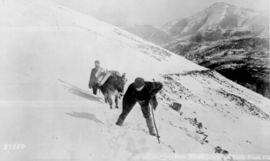
 These hikers are negotiating the last few switchbacks near the top of the Barr Trail. |
 The view to the northeast from the top of Pikes Peak. |
 Pikes Peak viewed from Colorado Springs. |
 Sign at the summit of the peak |
A picture of the Devil's Head Lookout with Pikes Peak in the background. |
 Driving through Colorado Springs, Pike's Peak towers over the city. |
 The observation tower atop Pike's Peak (1959) |
View of Pikes Peak from Rock Park in Castle Rock. |
 View of Pikes Peak from I-25 in Castle Rock. |
See also
|
|
References
Notes
- ↑ 1.0 1.1 "NGS Data Sheet for Pikes Peak". National Geodetic Survey. http://www.ngs.noaa.gov/cgi-bin/ds_mark.prl?PidBox=JK1242.
- ↑ "Pike's Peak". National Historic Landmark summary listing. National Park Service. http://tps.cr.nps.gov/nhl/detail.cfm?ResourceId=149&ResourceType=Site. Retrieved 2007-10-15.
- ↑ Joseph Scott Mendinghall (December 1, 1975) (PDF). National Register of Historic Places Inventory-Nomination: Pike's Peak. National Park Service. http://pdfhost.focus.nps.gov/docs/NHLS/Text/66000245.pdf. Retrieved 2009-06-22 and Accompanying 5 photos, from 1975.PDF (1.14 MB)
- ↑ Jon Karroll (2009-07-28). "Clock Ticking On Pikes Peak Paving Project". KRDO News Channel 13. http://www.krdo.com/Global/story.asp?S=10806522. Retrieved 2009-08-28.
- ↑ "Paving Pikes Peak -- slow and spendy defines the race". The (Colorado Springs) Gazette. 2006-11-26. http://findarticles.com/p/articles/mi_qn4191/is_20061126/ai_n16872302/. Retrieved 2009-08-28.
- ↑ 14ers.com
- ↑ OneDayHikes.com
- ↑ http://www.coloradoskihistory.com/lost/pikespeak.html
Further reading
- Rocky Mountain National Park: High Peaks: The Climber's Guide, Bernard Gillett, (Earthbound Sports; 2001) ISBN 0-9643698-5-0
- Rock and Ice Climbing Rocky Mountain National Park: The High Peaks, Richard Rossiter, (Falcon; 1996) ISBN 0-934641-66-8
External links
- Manitou Springs: The Gateway to Pikes Peak | Official Visitor's Site
- The Pikes Peak Web site
- U.S. Geological Survey Geographic Names Information System: Pikes Peak
- Live webcam view of Pikes Peak
- Rocky Mountains @ Peakbagger
- Santa Fe Trail Research Site
- Satellite Image of Pikes Peak from Google Maps
- Pikes Peak on 14ers.com
- Pikes Peak on Bivouac.com
- Pikes Peak Country "Pikes Peak Travel Information" page
- Pikes Peak Cog Railway "About Pikes Peak" page
- Pikes Peak weather forecast
- Pikes Peak Panoramic Camera
- Computer generated summit panoramas North South index
|
||||||||||||||||||||||||||||||||||||||||||||||||||||||||||||||
|
|||||||||||||||||
|
||||||||||